Activity overview
The Bass Non‑production Well Operations (Suspended Wells) Environment Plan (EP) covers the continued temporary suspension and monitoring of the existing Trefoil‑1 and Yolla‑1 offshore wells until they can be permanently plugged and abandoned.
The wells were drilled vertically to explore prospective geological structures and were subsequently suspended as potential future production wells. Neither well has been completed or used for commercial hydrocarbon production and, as a result, they are not connected to any existing pipeline or production facilities. No new drilling or construction activities are proposed.
In line with regulatory requirements, Beach is undertaking a 5‑year review of the Suspended Wells EP to support the continuation of these ongoing activities.
Beach also has an accepted EP to plug and abandon three Bass wells (White Ibis‑1, Trefoil‑1 and Yolla‑1). The White Ibis‑1 well was subsequently plugged and abandoned in 2025 under the Offshore Gas Victoria Drilling and Plug and Abandonment EP and no longer requires environmental approval under the Offshore Petroleum and Greenhouse Gas Storage (Environment) Regulations 2023. Plug and abandonment of Trefoil‑1 and Yolla‑1 is scheduled for later in 2026. If these activities are not completed by August 2026 (for example, due to scheduling or operational constraints), a review of the Suspended Wells EP is required to allow continued monitoring of the wells until they can be permanently plugged and abandoned.
The purpose of the proposed activity is to maintain well integrity and environmental protection while the wells remain suspended.
The activity involves routine inspections of the seabed wellheads to ensure they remain safe and secure while they are not in use.
Inspections will be carried out using a specialised inspection vessel and a remotely operated underwater vehicle (ROV). The ROV inspection vessel will use dynamic positioning systems to maintain its position and is not expected to anchor. It will be similar to vessels commonly used in the offshore oil and gas industry. Specialist operators will use the ROV to visually inspect each wellhead and the surrounding seabed without disturbing the seafloor.
During routine inspections of the Yolla-1 wellhead in 2023, small intermittent gas bubbles were observed, with subsequent ongoing monitoring showing no increase in frequency or size to date. The last inspection was performed late-2025. Beach has reported the observations to NOPSEMA and continues to manage the well in accordance with an accepted Well Operations Management Plan.
Inspections will be undertaken in accordance with the applicable requirements for each well. Inspections will be carried out at least once every 12 months.
Each inspection campaign is expected to take 1 to 3 days, depending on weather and sea conditions.
The actual inspection of each wellhead will take around 1 to 2 hours.
Vessel operations may occur during the day or night for the short duration of the activity.
The activities are being carried out in the Bass Strait, within offshore commonwealth waters.
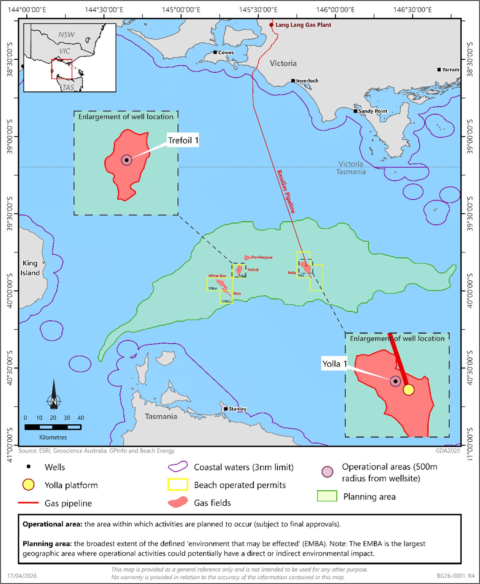
The Trefoil-1 well is located in retention lease T/L5 and the Yolla 1 well is located in production licence T/L1 (see map below).
At its nearest points, the activity area is located 99 km north of Stanley in Tasmania and 107 km east of King Island. The activity occurs in water depths ranging from 60 m to 80 m.
Operational and planning area map
Beach is undertaking a 5‑year review of the Bass Suspended Wells EP in line with regulatory requirements to cover ongoing activities.
The activities require ongoing environmental approval under the Offshore Petroleum and Greenhouse Gas Storage (Environment) Regulations 2023 (Regulations), which are regulated by the National Offshore Petroleum Safety and Environmental Management Authority (NOPSEMA).
An EP must be prepared and accepted by NOPSEMA for operations to continue. The EP must include:
- a description of the existing environment
- a description of the proposed activities
- an evaluation of environmental impacts and risks
- environmental performance outcomes, standards and control measures
- implementation and reporting requirements.
The EP must also demonstrate that consultation has been carried out with relevant persons - that is, people or organisations whose functions, interests or activities may be affected - in accordance with the Regulations.
The operational area (see map) is where the activities described in the EP are planned to occur, subject to final approvals.
The planning area (see map) represents the broadest extent of the defined environment that may be affected (the environment that may be affected – EMBA), subject to final approvals. The EMBA is the geographic area where the operational activities could potentially have a direct or indirect environmental impact.
The EP includes a detailed description of the environment within the operational area and the EMBA. A range of marine fauna are known or may occur in these areas, including:
- Blue whales, particularly during the summer months
- Southern right and humpback whales, particularly during the winter months
- Fin and minke whales
- Dolphin and shark species throughout the year
- Several species of foraging and migratory seabirds, including little penguins, and shearwater and albatross species
- New Zealand and Australian fur seals throughout the year
- Migratory turtle species
No activities are proposed within any marine parks. However, the EMBA overlaps the Boags Australian Marine Park.
Socio‑economic and cultural values and sensitivities within the operational area and EMBA include:
- Commonwealth‑managed fisheries, including:
- Bass Strait Scallop Central Zone Fishery (EMBA only)
- Southern and Eastern Scalefish and Shark Fishery, including the shark gillnet sector (EMBA and operational area)
- Coastal communities and onshore and offshore tourism activities
- Sea Country cultural values and sensitivities held by First Nations peoples
- Other commercial operations, including offshore petroleum and renewable energy activities, and the Victorian Desalination Plant
Beach recognises the environmental, cultural heritage, social and economic values within the operational and planning areas and has a strong track record of safe and environmentally responsible operations. Beach operates in accordance with the performance measures set out in accepted EPs and safety cases.
The EP identifies potential environmental risks and impacts associated with the activities and sets out performance outcomes, standards and control measures. These measures are designed to reduce and manage risks and impacts to as low as reasonably practicable (ALARP) and to acceptable levels. ALARP is an established assessment principle used in the oil and gas industry to assess and reduce impacts and risks that cannot be eliminated.
The control measures are developed in line with the principles of ecologically sustainable development, and Beach operates in compliance with NOPSEMA‑accepted Safety Cases and Well Operations Management Plans.
A more detailed summary of the key risks and impacts, mitigation measures and management plans is available here. For further information on how NOPSEMA assesses ALARP, see the ALARP Guidance Note.
Beach recognises First Nations groups and their spiritual and cultural connection to the environment, including Sea Country.
Beach’s operations occur in the Sea Country adjacent to the coastal First Nations groups Bunurong Land Council Aboriginal Corporation in Victoria and the Circular Head Aboriginal Corporation in North West Tasmania.
Beach will consult with these groups, as well as any newly identified relevant First Nations groups, to identify cultural values and sensitivities associated with Sea Country and to address any potential impacts and control measures to be included in the revised EP.
Exclusion zones
All vessels are required to abide by a 500 m petroleum safety zone (PSZ) around the Trefoil-1 and Yolla-1 well locations. PSZs are administered by NOPSEMA under Section 616 of the Offshore Petroleum and Greenhouse Gas Storage Act 2006 (Cth). The PSZ is a safety exclusion zone restricting all vessel and diver access except those authorised to do so by NOPSEMA PSZs are shown as a ‘Restricted Area’ on navigation charts.
Operating safely and maritime safety protocols
Safety takes precedence in every activity undertaken by Beach. Vessels associated with the activity will operate in accordance with Australian Maritime Standards, regulated by the Australian Maritime Safety Authority including:
- Notifications to the Australian Hydrographic Office before mobilising and demobilising for construction, maintenance and survey activities in the operational area.
- Providing advanced notice of vessel contact details for construction, maintenance and survey activities to other vessels and marine users.
- Communicating with other vessels using standard maritime protocols.
- Maintaining safe operating distances.
- Compliance with Navigational Safety requirements, including lighting and Automatic Identification System.
Given the nature of the activities, there is a highly unlikely risk of a marine vessel fuel release during EP activities. Beach’s standard operating procedures require emergency response plans in all EPs. These plans are developed using worst-case spill modelling of all potential hydrocarbon release scenarios in the local area, assuming no control measures are in place. The modelling calculates the transport, spreading, entrainment and evaporation over time, based on:
- prevailing metocean conditions (wind, wave and climate) on a seasonal basis
- the volume released
- the physical and chemical properties for the hydrocarbon released.
The model output presents a combination of 200 different spill simulations for each scenario and is used to inform emergency planning and define the EMBA. The model output and resulting EMBA is not representative of the full extent of a single, highly unlikely release of hydrocarbons.
The revised EP will describe the EMBA and include an assessment of the likelihood and consequences of any hydrocarbon release, which must be reduced to ALARP through control measures and detailed response plans. For more information on hydrocarbon release modelling and why it is required for the preparation of EPs, click here to watch NOPSEMA’s video.
An emergency response plan describes the arrangements that must be in place for responding to and monitoring any release of hydrocarbon, including:
- 24/7 on-call team for rapid response clean-up actions, including mobilisation of personnel and equipment
- 24/7 on-call team for modelling and monitoring of a hydrocarbon release to inform response activities, and monitoring of effectiveness of response activities
- control measures necessary for ensuring rapid response and maintenance of capabilities (personnel and equipment).
These arrangements are based on the worst-case event associated with the activities, to ensure that Beach has the appropriate level of response arrangements and capability.
Beach maintains a current contract with the Australian Marine Oil Spill Centre based in Geelong for access to spill response resources and personnel. The Victorian Department of Transport is the control agency for marine pollution emergencies within 3 nautical miles of the coast. Beach also conducts exercises to test the emergency response plans and identify any issues and improvements before, and during operations.


