Bass Gas Operations produces natural gas and condensate from the Yolla gas field in the Bass Strait. The gas field is serviced by the Yolla-A Offshore Platform (Yolla Platform), and an approximately 147 km subsea pipeline that transports the gas and liquids from the platform to the Victorian mainland via a coastline crossing near Kilcunda.
The associated 32 km onshore pipeline terminates at the Lang Lang Gas Plant (LLGP) where natural gas is processed before being distributed to the domestic east coast market, delivering energy to homes, businesses and industry.
Commercial production of gas from the Yolla field started in June 2006. Recent forecasts predict that production has the potential to extend to 2030, however there is also a possibility it could finish earlier.
In accordance with regulatory requirements Beach Energy (Beach) is undertaking a 5-year review of the Bass Gas Offshore Operations Environment Plan (EP) to cover ongoing production operations.
This page covers the EP’s scope, which includes the operation of the offshore wells, Yolla Platform and pipeline, and the ongoing maintenance and inspections to ensure safe ongoing field operations.
Commercial production of gas from the Yolla field started in June 2006. Recent forecasts predict that production has the potential to extend to 2030, however there is also a possibility it could finish earlier.
Production from the wells and processing on the Yolla Platform occur 24 hours a day, seven days a week.
The activities are being carried out in the Bass Strait, within offshore Commonwealth and Victorian State waters.
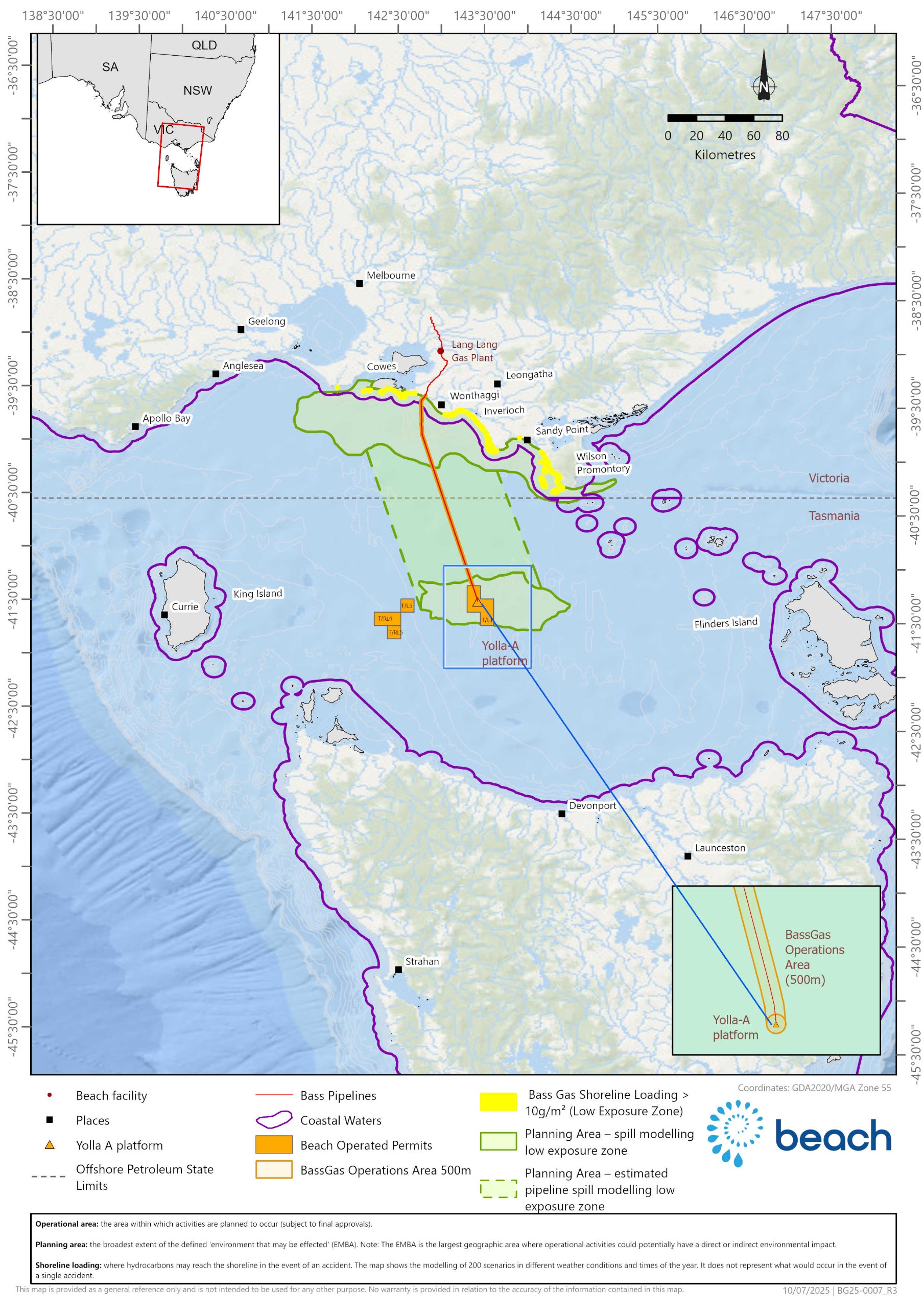
The Yolla gas field and Yolla Platform are located in Production Licence T/L1, 147 km south of Kilcunda, Victoria, in a water depth of 80 m.
The subsea pipeline is located in Pipeline Licences T/PL2 and VIC/PL34 (see map).
Activity and planning area map
Activities
The Yolla Platform is typically staffed part-time on a two-week-on and two-week-off roster. At other times, the platform has varying levels of staffing to support routine and non-routine operational, inspection, and maintenance activities. The Yolla Platform can accommodate up to 44 people.
The processing facilities on the Yolla Platform are designed to separate raw gas from the reservoir into gas, condensate and produced formation water streams. The gas is compressed and comingled with the condensate and exported via the raw gas pipeline to the onshore LLGP. Treated produced formation water is released to the sea at the platform. Gas is not routinely vented from the platform to the surrounding atmosphere. The flare is used as the main safety system to release gas and condensate in the case of an emergency.
Routine and non-routine activities described in the EP involve the use of both supply and support vessels and helicopter movements to transport personnel to and from the Yolla Platform.
Routine operational, inspection and maintenance activities include:
- Platform topside cleaning, inspection, repairs and maintenance
- Vessel-based remotely operated vehicle pipeline inspections
- Diving activities to conduct inspections, maintenance and repairs
- Geophysical surveys along the pipeline route
- Pipeline surveys and inspections.
Non-routine operational, inspection and maintenance activities include:
- Well intervention
- Workover
- Platform maintenance and shutdown inspection campaigns
- Pipeline repair and replacement campaigns
- Environmental surveys / monitoring
- Activities to be undertaken to safely suspend production activities ahead of decommissioning if required during the life of this EP.
Environment and regulations
NOPSEMA regulates activities in commonwealth waters in accordance with the Offshore Petroleum and Greenhouse Gas Storage (Environment) Regulations 2023[1]. The Victorian Department of Energy, Environment and Climate Action (DEECA) regulates offshore activities in Victorian state waters in accordance with the Offshore Petroleum and Greenhouse Gas Storage Regulations 2021 (Vic) [2]. Both sets of regulations are referred to as Regulations in this page. In accordance with the Regulations, the EP is required to be accepted by both NOPSEMA and DEECA for ongoing operations.
An EP must include:
- a description of the existing environment
- a description of the proposed activities
- an evaluation of the impacts and risks, environmental performance outcomes and controls, implementation strategy, and reporting requirements.
[1] Under the Offshore Petroleum and Greenhouse Gas Storage Act 2006 (Cth)
[2] Under the Offshore Petroleum and Greenhouse Gas Storage Act 2010 (Vic)
The operational area (see map) is where the activities described in the EP are planned to occur (subject to final approvals).
The planning area (see map) is the broadest extent of the defined ‘environment that may be affected’ (EMBA) (subject to final approvals). The EMBA is the geographic area where operational activities could potentially have a direct or indirect environmental impact.
The EP includes a detailed description of the environment in the operational area and the EMBA, where there is a variety of marine fauna that are either known to occur or may occur, including:
- Blue whales, particularly during the summer months
- Southern right and humpback whales, particularly during the winter months
- Fin and Minke whales
- Dolphin and shark species throughout the year
- Several species of foraging and migratory sea birds including Little Penguins, and shearwater and albatross species
- New Zealand and Australian fur seals throughout the year
- Migratory turtle species.
There are no activities occurring within marine parks; however the following National Marine Parks and State Marine Protected areas are within the EMBA:
- Cape Liptrap Coastal Conservation Park
- Yallock-Bulluk Marine National Park
- Powlett River Mouth, Nationally Important Wetland.
The Western Port, a Ramsar-listed site (wetlands of international importance designated under the Ramsar Convention on Wetlands) is within 10 km of the EMBA:
- Socio-economic and cultural values and sensitivities with the activity and planning areas include Commonwealth-managed fisheries including Eastern Tuna and Billfish Fishery, Bass Strait Scallop Central Zone Fishery, Skipjack Tuna Fishery, Southern Bluefin Tuna Fishery, Small Pelagic Fishery, Southern Squid Jig Fishery, Southern and Eastern Scalefish and Shark Fishery.
- Commercial and recreational marine and port communities along the Victorian coastline
- Coastal communities and onshore and offshore tourism activities
- Sea Country cultural values and sensitivities held by First Nation peoples
- Other commercial operations including offshore petroleum and renewable energy activities and the Victorian Desalination Plant.
Beach recognises the environmental, cultural, heritage, social and economic values in our operational and planning areas and has a proud track record of successful safety and environmental performance, adhering to performance measures set out in accepted EPs and safety cases.
The EP details potential risks and impacts on the environment and provides performance outcomes and standards. It also details control measures to reduce and manage environmental impacts and potential risks to ‘As Low As Reasonably Practicable’ (ALARP) and acceptable levels. ALARP is an assessment principle commonly used in the oil and gas industry to assess and reduce potential impacts and risks that cannot be eliminated. The control measures follow the principles of ecologically sustainable development. They include:
- The Yolla Platform, offshore pipelines and wells are marked on the Australian Hydrographic Office’s navigational charts and are surrounded by an existing 500 m petroleum safety zone (PSZ) (see ‘Exclusion zones’ below).
- Beach-utilised vessels are required to comply with applicable marine regulations and observe the minimum approach distances to whales and dolphins as set out in national guidelines.
- Ongoing engagement with other marine users in the area throughout the life of the operations.
- Venting and flaring activities at the Yolla Platform is limited to that required for safe operations.
- Continuous monitoring of produced formation water discharges.
- Beach operates in compliance with NOPSEMA-accepted safety cases and Well Operations Management Plans.
- The risk of loss of containment of hydrocarbons or chemicals is managed through equipment design, and the implementation of asset integrity and maintenance programs. In addition, process parameters are monitored 24/7 by trained and competent personnel.
A more detailed summary of the key risks and impacts, mitigations and management plans can be found here. For information on how NOPSEMA assesses ALARP, see ALARP Guidance Note.
Beach recognises First Nations groups and their spiritual and cultural connection to the environment.
Beach’s operations occur in the Sea Country adjacent to the coastal First Nations groups Bunurong Land Council Aboriginal Corporation, Gunaikurnai Land and Waters Aboriginal Corporation, Flinders Island Aboriginal Association. Beach consulted with these groups for the development of the EP.
Beach will continue to consult with these groups, as well as any newly identified relevant First Nations groups, to identify cultural values and sensitivities associated with Sea Country and to address any potential impacts and control measures to be included in the revised EP.
All vessels are required to abide by a 500 m PSZ around the Yolla Platform. PSZs are administered by NOPSEMA under Section 616 of the Offshore Petroleum and Greenhouse Gas Storage Act 2006 (Cth) (OPGGS Act).
The PSZ is a safety exclusion zone restricting all vessel and diver access and, along with a 3 km cautionary zone, is monitored from the Yolla Platform to minimise the risk of vessel collision.
Entry into PSZs is prohibited to all vessels except those authorised to do so by NOPSEMA (as detailed in a gazetted notice) or those vessels exempted under Section 615 of the OPGGS Act. PSZs are shown as a ‘Restricted Area’ on navigation charts.
Safety takes precedence in every activity undertaken by Beach. The Yolla Platform and offshore portion of the raw gas pipeline have a dedicated Safety Case accepted by NOPSEMA.
Support vessels attending the Yolla Platform and the subsea pipeline for supplies and maintenance activities will operate in accordance with Australian Maritime Standards, regulated by the Australian Maritime Safety Authority including:
- Notifications to the Australian Hydrographic Office before mobilising and demobilising for construction, maintenance and survey activities in the operational area.
- Providing advanced notice of vessel contact details for construction, maintenance and survey activities to other vessels and marine users.
- Communicating with other vessels using standard maritime protocols.
- Maintaining safe operating distances.
- Compliance with Navigational Safety requirements, including lighting and Automatic Identification System.
There is an unlikely risk of a hydrocarbon gas, condensate or marine vessel fuel release during EP activities.
Beach’s standard operating procedures require emergency response plans in all EPs. These plans are developed using worst-case spill modelling of all potential hydrocarbon release scenarios in the local area, assuming no control measures are in place. The modelling calculates the transport, spreading, entrainment and evaporation over time, based on:
- prevailing metocean conditions (wind, wave and climate) on a seasonal basis
- the volume released
- the physical and chemical properties for the hydrocarbon released.
The model output presents a combination of 200 different spill simulations for each scenario and is used to inform emergency planning and define the EMBA. The model output and resulting EMBA is not representative of the full extent of a single, highly unlikely release of hydrocarbons.
The revised EP will describe the EMBA and include an assessment of the likelihood and consequences of any hydrocarbon release, which must be reduced to ALARP through control measures and detailed response plans. For more information on hydrocarbon release modelling and why it is required for the preparation of EPs, click here to watch NOPSEMA’s video.
An emergency response plan describes the arrangements that must be in place for responding to and monitoring any release of hydrocarbon, including:
- 24/7 on-call team for rapid response clean-up actions, including mobilisation of personnel and equipment
- 24/7 on-call team for modelling and monitoring of a hydrocarbon release to inform response activities, and monitoring of effectiveness of response activities
- control measures necessary for ensuring rapid response and maintenance of capabilities (personnel and equipment).
These arrangements are based on the worst-case event associated with the activities, to ensure that Beach has the appropriate level of response arrangements and capability.
Beach maintains a current contract with the Australian Marine Oil Spill Centre based in Geelong for access to spill response resources and personnel. The Victorian Department of Transport is the control agency for marine pollution emergencies within 3 nautical miles of the coast. Beach also conducts exercises to test the emergency response plans and identify any issues and improvements before, and during operations.


